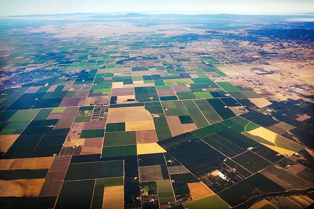
From the Archives: Helping Shorebirds in California's Central Valley
Changing irrigation schedules can make a big difference for migrating birds
For this week’s Green Dispatch I’m dipping into a previously published post from March 2021, a post I consider important but didn’t get a lot of readership. I’m hoping it reaches more folks now. Before getting to that, I’d like to touch on a subject that has very much been on my mind lately: misinformation.
, writing about misinformation on his Substack, The Honest Broker, reminded me how much effort we who care for the environment must expend at fighting mendacity and outright lies. Three of the Substacks I subscribe to are devoted solely to dispelling untruths about the environment. and skewer the lies of plastics manufacturers, polluters, and the fossil fuel industry in their Substack HEATED. With his REDD-Monitor, concentrates on the misinformation and disinformation that serves the carbon credits market. The lies of the fossil fuel industry are the target of ExxonKnews.I will be writing about misinformation in an upcoming Green Dispatch. Until then, I’d like to know what you think.
And now, to the archive post:
California’s Central Valley
Mountains run the length of California, from Oregon down to the border with Mexico, Yet right in the middle of this rugged terrain is a big, very flat expanse called the Central Valley. From Yuba City in the north down to Bakersfield, the Central Valley covers about 20,000 square miles. That’s about the size of Vermont and New Hampshire put together.
California is a land of extremes. The highest point in the 48, Mount Whitney (elevation 14,505 feet), is in California, as well as the lowest, Badwater (elevation -282 feet), in Death Valley. The Central Valley mirrors these extremes. In a state with high tech and billionaires, the Central Valley has some of the most extreme poverty in the country.
Besides being big and flat, the soil is fertile in the Central Valley, and farmers can ship in water, so it’s where folks grow a lot of food. More than 250 different crops are grown in the valley, worth an estimated $17 billion per year. One quarter of all of the food in the U.S. is produced in California’s Central Valley.
It can be a curious thing to zoom in to this valley with Google Earth to see a large Mondrianesque expanse of human-made rectangles and see how we have transformed the landscape. The weather in the valley is also greatly affected by humans. A lot of the water that irrigates the crops evaporates and then condenses soon after rising from the plain, producing large fog banks. One day many years ago, I drove through about 150 miles of fog in the Central Valley.

Helping Shorebirds in the Central Valley
Before the 1850s, the Central Valley had more than 6000 square miles of wetlands. More than 90 percent of that is now gone. Yet the Central Valley continues to be habitat for migratory birds in the remaining wetlands and even in some of the farms. It is estimated that almost five million waterfowl live among the wetlands and farms through the winter, and more than half a million shorebirds, representing over 30 species—including dowitchers, plovers, sandpipers, black-necked stilts, and avocets—rely on the habitats of the Central Valley during their spring migration, from April through May.
The habitats these birds use include corn and rice fields that farmers flood after their fall harvests. For a shorebird, if an area is filled with shallow water, they don’t know or care if rice or corn had been grown there weeks before. To them, it looks like habitat.
These wetlands are important to the birds. Without them, there aren’t a whole bunch of other places along their flyways for the birds to stop. Without these places—where the birds can rest and eat—migration may be impossible, jeopardizing their existence. The managed wetlands in the Central Valley are reliable habitats for the birds.
One of the wetlands areas is the Grasslands Ecological Area (GEA), a 160,000-acre multi-habitat preserve in the Central Valley located mostly within Merced County. About 30 percent of the land in the GEA is privately owned and farmed. Though they flood their wetlands, farmers have typically drained their farmlands in February and March, before the majority of shorebirds pass through the valley in mid-April.
A team of scientists had a simple question. What if the farmers delayed the onset of drainage and drained the lands more slowly than the one-to-three weeks of traditionally managed farmlands?
They had some farmers give it a try for three years. During this time the scientists monitored 107 areas that were drained slowly and 73 traditionally drained areas. In all, they completed 1,245 bird surveys of all the areas.
The scientists found the shorebirds used the slowly draining land to a much greater degree than the traditionally managed land. They found overall 21 times as many birds in the slowly drained land than in the traditionally drained lands. Ninety-six percent of the shorebirds were observed using the slow-draining farmlands. The scientists published their results in the Journal of Fish and Wildlife Management in December 2020.
The scientists suggest incentives for the farmers to drain their lands later and more slowly in the Central Valley. Adopted on a large scale, shorebirds could continue migrating through California much as they have for thousands of years.


Every concerned person should educate themselves on propaganda techniques.
I hope that the incentives work.